Media Log


Story of Jeju island by Mr.Dee

The view of Provincial Gotsawal park


2024. 12. 2.
The lava forest named ‘Got-jawal’ in Jeju island is a unique forest. Originally, the word Gotjawal is a combination of two words, ‘got’ and ‘jawal’. ‘Got’ means bush with thorns and ‘Jawal’ means a place with gravels and rocks in the forest.

Since when the word ‘Gotjawal’ has been used to refer to this unique forest that can be only found in Jeju island.  In fact, the word 'Gotjawal' is said to have been created by the late Song Si-tae by combining 'Got' and 'Jawal' while he was studying this forest.

We can find the characteristics of’Gotjawal’ in the creation of Jeju island that was formed recently compared to the mainland Korean peninsula. The Korean peninsula was formed around 1 billion 500 million years ago and Jeju island was formed around 1 million 400 thousands years ago. It’s very time different. The characteristic of the mainland is that because it is old, granite that hardened underground and became lava is exposed on the surface. But compared to this, the land of Jeju Island is very young, so it still appears less weathered.

Here, ‘weathering’ refers to the process in which large stones turn into soil over a long period of time as rocks and water are affected by temperature. Jeju Island is famous for having rough soil and lots of rocks because it has not been weathered much. This also applies to Jeju Island’s forests. If you go into Jeju Island’s forests, there are more rocks than soil. These rocks are formed when lava flows became hardens. When volcano erupted lava flows and it becomes hardens then it has been broken into pieces over time. After that a forest has been formed on top of these broken rocks. The forest of Jeju island formed this way is called ‘Gotjawal.’

There are lots of rocks which has not yet been weathered yet in the Gotjawal forests

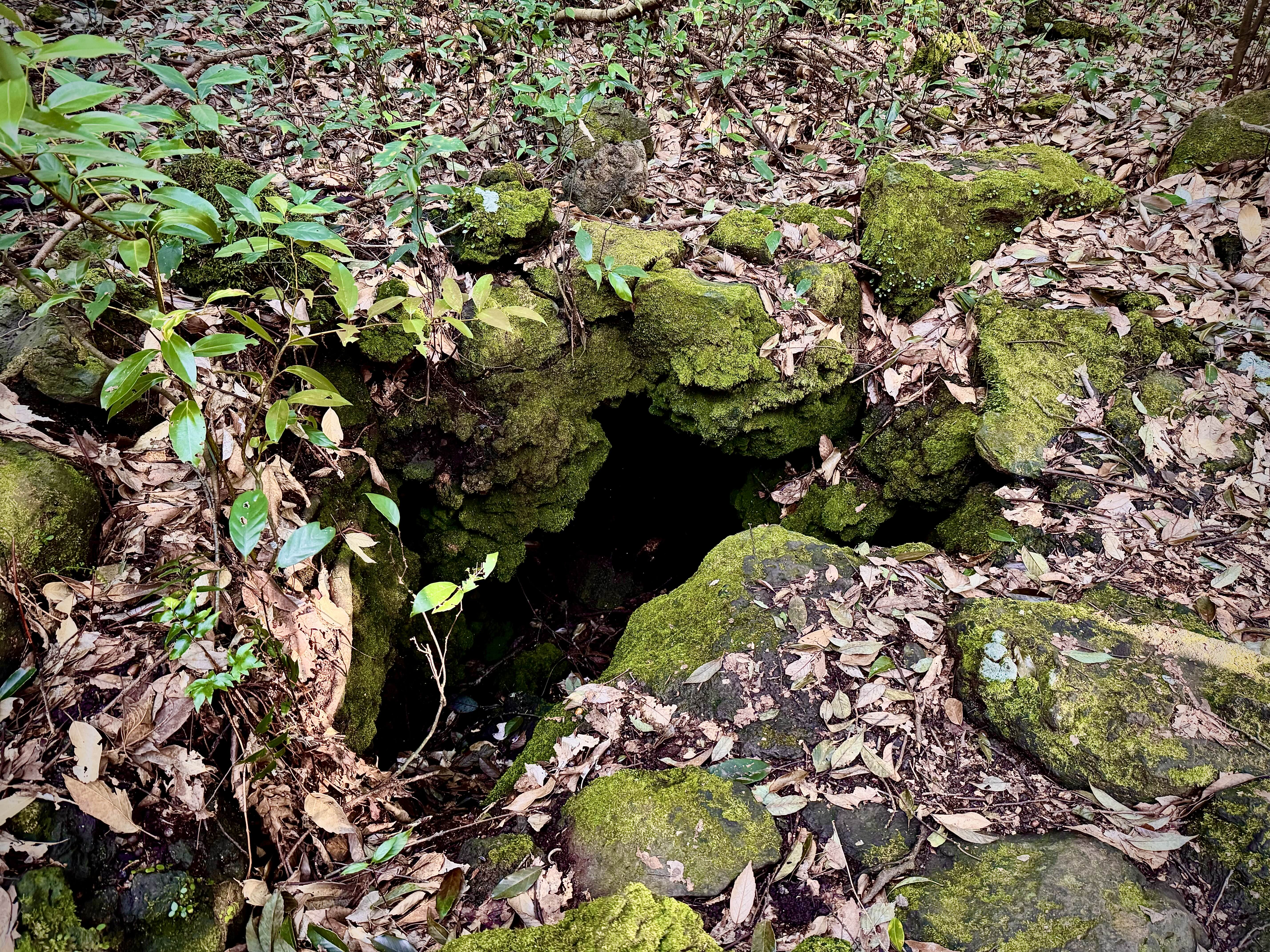
Gotjawal is a forest that formed on a terrain where lava flows and becomes rocks. Another characteristic of lava flows is lava tubes. The process of forming a lava tubes is that when low viscosity lava flows, the outer surface hardens and it becomes rock, and when all the hot liquid lava inside soaked out, an empty space is created. This is the process of creating a lava tubes. It could be big or small ones. Anyway, then, when the solidified lava flows and splits and becomes rocks and piles up, an empty space is created inside. This empty space collapses over time. The terrain where the lava cave and lava tube are exposed by this collapse is called  ‘sumgol.’

What role does this ‘sumgol’ play in the Gotjawal forest? First, it stores water. Since there is an empty space underground, when it rains, water flows into it and acts as an underground water storage. Jeju Samdasoo, Jeju mineral water, is also drawn from here in Gotjawal. Second, it emits air of a certain temperature. The temperature of the air is said to be around 12-15 degrees. Since air of a similar temperature is always emitted, cold-temperate plants and temperate plants that would have disappeared long ago can still exist in Gotjawal forests. That is why southern-limit plants and northern-limit plants can coexist in Gotjawal. This is a unique feature of Gotjawal forests that does not exist in other forests.

‘Sumgol’ literally means breathing vent under ground of Gotjawal forest.

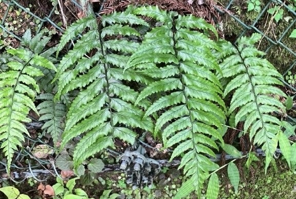
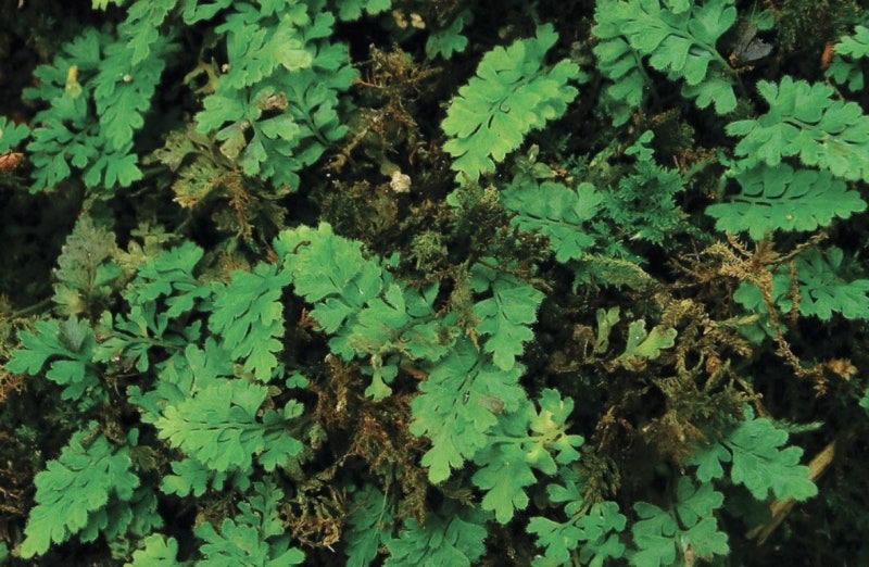
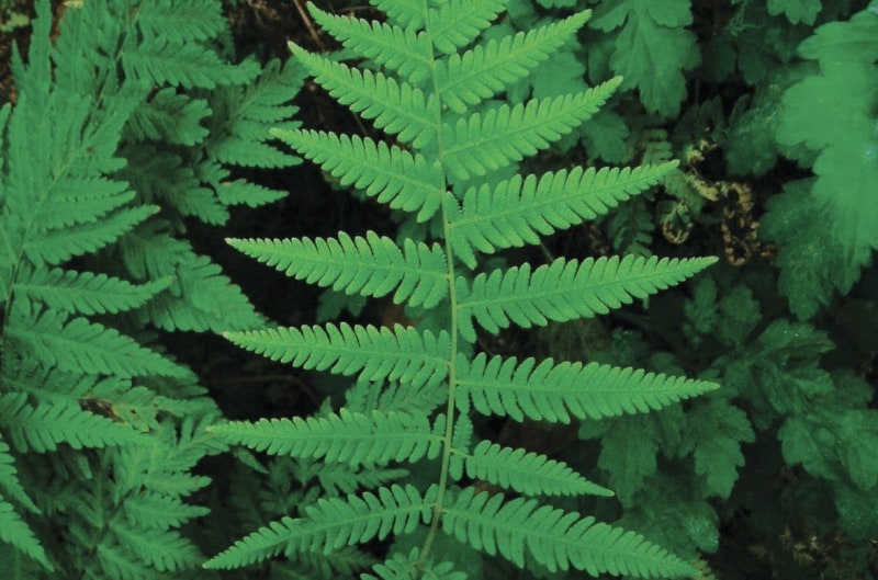
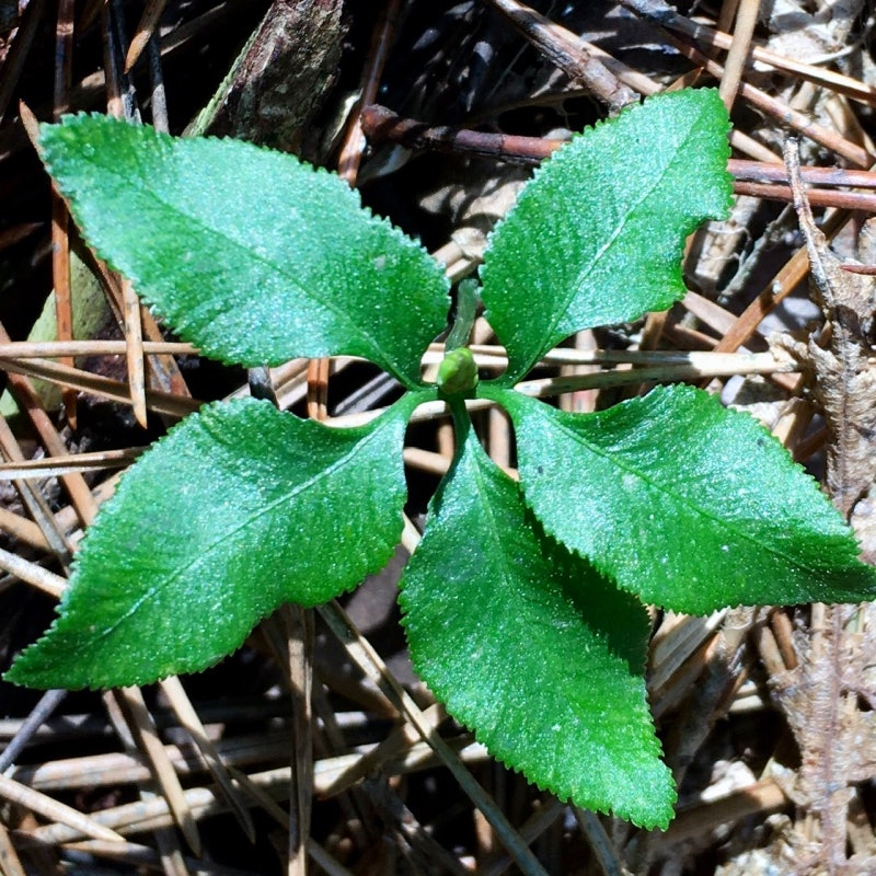
Then which plants are northern limit and which plants are southern limit plants? First of all, the ferns with tenacity survived. The representative southern ferns, wrinkled ferns, are commonly found around the Gotjawal Forest. The small ferns, which are usually found above 1,000m of sea level, are also found here in Gotjawal Provincial Park, Jeju, which is less than 300m above sea level. The raccoon ferns are said to be ferns found around the Amnok River in Korea. This raccoon ferns also coexist with other plants here. In particular, the Jeju Sam fern, a unique species found only on Jeju Island, is found in the Gotjawal Forest.

The reason why Jeju Island has such a unique lava forest among numerous volcanic areas around the world is because Jeju Island is a very young land, which means it is less weathered. Jeju Island is neither tropical nor temperate, but rather subtropical. Jeju Island is only about 110km from the mainland, but the warm current flowing around the island makes the winter mild. For this reason, Jeju Island has a subtropical climate.

In addition, the Gotjawal Forest is home to the 2nd class endangered wild plants designated by the Ministry of Environment, such as the dogwood and the bill tree, as well as 7 species of endangered animals, such as the hawk, the bald eagle, the great hawk, the palatine tit, and the long-tailed tit.

Southern limited plant. Wrinkled fern
Above 1000m of sea level plants. Small fern
Raccoon fern are found Amrok river area(north tip of Korean Peninsula
Jeju Sam fern. Endangerd plant and only found in Jeju island.

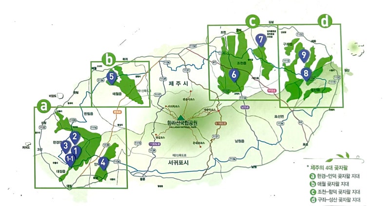
Until a few decades ago, the Gotjawal forests of Jeju Island were useless land that could not be farmed. In the 1980s, golf courses began to be built one after another in Jeju Island, and most of them were built inside of the Gotjawal forests area. Not only golf courses, but also new cities were built on top of the Gotjawal forests by digging them up. As a result, the Gotjawal forests that remain in Jeju Island today are only those shown on the map below.


Jeju Island is already sick amidst endless debates over between development and preservation. I think we need intense research on how to develop and what to preserve. It will be too late to restore nature that has been destroyed once. The more you see and know, the more you feel the preciousness of it. I hope Jeju Island's lava forest 'Gotjawal' will not be destroyed any more.


Jeju island is an absolute volcanic island.

In Jeju island, there are more than 360 diverse volcanic craters as well as 120 lava tubes formed by volcanic activities. Furthermore, it also has the highest Mt in South Korea called Hallasan.

Various scenic view from volcano is magnificent comparing to other volcanic places.

Due to the recognition of the natural scenery, geological and biological value, Jeju island has been registered by UNESCO as natural, geological and biological heritage of the world.
It also has been designated as one of New 7 Wonders of nature.
Needless to say, Jeju island is a treasure island in Korea.

However, I want you to know we have different culture and life style from the main land(Korea) and other rest of the world.

Jeju island has not only beauty of nature but also has a long history of Tamra kingdom.

Jeju island had been use to be exile prison since kyore dynasty with a prohibition of going out of its island for 300 years.
Thanks to this ironic history Jeju island has most traditional culture. And it has been known as a rebellious island because there were rebels and suppressions repeatedly.


Jeju island keep stimulating interest of foreign visitors with gut,myth which Korean society still doesn't have generosity of understanding.


You can access to the freshest food in Korea because it is an island.

So, slow food is possible. People get gather at 5 days market to buy Jeju red carrots, potatoes, dropwots etc.

Jeju island has been known for abundance in winds, stones and women.

Islanders have been venerable to nature to struggle against wind. The land is barren to dig out numerous stones for farming.

And women always had been outnumbered to men dud to lack of men.

Nowadays 3 abundant things are beautified for story telling in Jeju island but actually they shows the pain of Jeju history.

But... We are making electricity by winds and we have stacked up stones to make walls which now are agricultural heritage of the world.
Jeju island has become a place where people from all over the world are interested in.


As time goes by, Jeju island has turned to be modernized and the ratio of man and woman becomes half to half. And the profession of woman diver endangers which is supposed to be registered as an intangible heritage of the world by UNESCO.

'Attration info' 카테고리의 다른 글

(Jeju travel Mr.Dee) fact of Jeju island  (0) 2015.01.08

It's been 4 years since I have changed my job.

Actually, I was an English teacher for elementaries but I got sick and tired of not going out the world. I really want to meet more diverse people from all over world.


One good thing for being an English speaking tour guide is that I can meet so many diverse people from all over the world.


This time, my clients came from Malaysia.


One thing I always have difficulties with Malay clients is that chooing a proper restuarant.

Not because of their nationality but because of their preference of food.


As you know, Black pork is one of the most famous food in Jeju island.

And Black pork meat is used in so many foods in Jeju island.

One of my favorite food pork noodles is one of the kind.


So that, Choosing a restaurant for muslims is very difficult thing.

Because they don't eat pork meat as well as any meat without Halla.


They are medical doctors and students.


I like students clients because I can see through them that they want to learn something about Korea and Jeju island.


So that suddenly I want to show them a real Jeju island.


Out of sudden, one of them asked me about K pop.


Then I just got an idea " A-ha there is common topic between us, that is a K-pop and drama".

"Ok. Let's start talking with this"


"Do you know Yu Jae-suk?" "Do you know his nick name?" "Do you know Moohan doJeon?" Well, they already knew about lots of thins on Korean TV program.


Well, there is no special things to break the barrier of the religions or cultures.

Just show them our things slowly then they will show us theirs.

I think it is a way of breaking cultural barriers.

Like this when we travel together we are the one.

We are going to share thinkings, We find our common things as well.

We went to the restaurant which serve Jeju traditional food.

The food name is 뚝빼기 they never seen abalone shells before and they were amazed by the beautiful inside of the shell.

They brought the empty shells to the wash room and wash them to keep them as a Jeju survirnior.

I think it is a good idea to have them from their food.


We hiked 'Youngsil' on the first day after abalone lunch.

They said they didn't have much experience to hike on the mountain.

We counldn't go to the top of the mountain. 

However, we enjoyed enough the beauty of Valley of mountain.


On the third day. It was rainning and windy.

I asked them if still going on the trip? At first they hesitated then I insisted to keep going. Well, they told me this is like a military training, fun training. they seemed happy. I should be a leader of the traveller. that is my job. some times push them, some times pull them up.
One thing I have more than they have is that experience and what they want is that my experience.


*Notice- This article is written by non-native English speaker.


Have you ever heard about lava columnar joints? When you travel in Jeju island you will see a lot of lava columnar joints. So, You might wonder what the lava columnar joints?

'Lava columnar joints' are basically lava rocks which cooled down touch very cold air. Just imagine that lava erupted on the top of mountain and it flowed down to the shore slope gently. The lava makes volcanic craters, lava forests, and at finally it becomes lava columnar joints. 


Trekkers traveling aound Jeju island esily find lava columnar joints especially in Seokwipo are where is located on south of Jeju island. The famous places are 'Ji-ssak-gaek', Gaek-gak, Jungbang waterfall area, and Tiger island. Acutally they are world famouns


<Beoseom; Tiger island is made by lava column joints>


Tiger island was a volcanic crater at first time. As time goes by the lelve of sea water has ascended and it became a seperated isalnd and it has been eroded by wind and wavies. If you imagine Sanbang Mt makes you understand easily


<Saek-Dal Jungmoon beach>


If you want to see Gaek-gaek lava columnar joint, you have to go detour along with Hayyat hotel. on the middle of on the way you can't miss the view of Jung-mun beach. Luxurious hotels are located surrounded by this beach.


You can see the rocks splited. They are the lava columnar joints. Next to the rocks there is a samll waterfall.

I listed many pictures, I hope you enjoy them. they are absolutely magnificent!


Foot prints. The sign someone has come to here. The Waves will sweep the sign and it turns out to be a white paper waiting for someone else next day.

Even my sign of coming here will be swept off. However, I want to leave my sign coming here.

This posting is what it is.


*Notice- this article is written by non native English speaker


Mt. Halla which rises 1,950m above sea level is the highest mountain in South Korea.
There is a crater and lake located at the summit of Mt Halla and its name is Baengnokdam(White deer rock lake) and about 40 parasite craters around the summit. A beautiful sight of steep and fantastic rock cliffs are designated in 1966 and 1970 as Nature Monument and National Park respectively, and in 2002 it was designated as a bio-reserve area by UNESCO.
As the peak of Mt.Halla is made of diverse volcanic characteristics, depending on the angle of one's view, one can feel its uniqueness. To the west of Baengnokdam crater, a steep shape formed by basalt lava of high viscosity is found and to the east, low viscosity basalt lava formed a gentle plateau. The south is so beautiful that it is captured in a folktale which states the story of immortals that played in the lake.


Mt. Halla is also a mountain where fir tree forest is found which is unique of its kind in the world.

At 1,400m above sea level an endemic species of cinder cones including pine trees are grown. It also possesses an outstanding biological research value in the study of cinder cones. Besides this at 1,700m, are distributed 39 different kinds of polar species which play very important part in the study of alpine life such as, jeju weasel, Jeju salamander, women diver snake, etc... are seen in Mt. Halla.
Well endowed with natural resources of scientific values, Mt. Halla is a noted mountain worldwide.


*Notice- this article is written by non native English speaker


'Seongsan ilchulbong' hydro crater is the most famous tourist spot in Jeju island.  
it rose from under the sea in a volcanic eruption over 5,000 years ago and this crater is the youngest one in Jeju island. Seongsan ilchulbong means 'Castle Mt Sun rise peak'.
It is registered by UNESCO as natural, geological heritage.

Eroded cliff on the crater


 Actually at first when it was erupted it was normal shape of crater but it has been eroded almost half of them for 5000 years. Geologists say that the eroded cliffs on the crater is valuable to study hydor volcanoes because it shows all the process of eruption. They can see the clear sedimentary layers on the rock. 


It shows different figures on different angles


It is located the eastern end of jeju island that's why it is called 'Sun rise peak' Every new year day the top of 'Seongsan ilchulbong' is crowded with people to see sun rising. If you are lucky you can see the magnificent sun rising but most of the days are clouded.
The similar volcano to 'Seongsan ilchulbong' is  'Surtsey' in Iceland. Comparing two volcanoes is that 'Surtsey' is too young to show all the process of eruption on the cliff while 'Seongsan ilchulbong' shows clearly.


Surtsey island in Ice land

After 5000 years later 'Surtsey island' will be like 'Seongsan ilchulbong'  I guess. The steepness and narrowness of the cliff make 'Seongsan ilchulbong' more visually appealing. It takes around 30min to go to the top and  during your climbing up , you will get a quite cool view of Seongsan village. Actually 'Seongsan ilchulbong' was independent island from jeju but Japanese has connected it in early 1940s to use this crater as military base.

view of Seongsan village


Not many people know that 'Seongsan ilchulbong' is a second crater. First crater is located on the east side of 'Seongsan ilchulbong'. It was erupted 300,000 years ago and it has been almost eroded. One interest thing is that the colours of rocks of the first crater is red because when it was erupted the level of sea was much below. And that atmosphere made the lava cool down slowly. 

the first crater in Seongsan ilchulbong


You can see the points on the top. There are 990 points on the top. When you see 'Seongsan ilchulbong' from the ocean it looks a huge castle because of the points. 


I think 'Seongsan ilchulbong' is the place worth to visit in jeju island. Try to be a geologist, then it intrigue your interest. Don't you think so?
more information click here http://en.wikipedia.org 


*Notice- this article is written by non native English speaker

This time I had a travel with Christina. Her name is Maria Christina San Jose from Philippine 
She is a neurologist, medical doctor. Sorry to her, first I thought she is a Chinese.
In this time, actually I had two customers, one was Christina and the other was Korean girl( I forgot her name). The Korean girl didn't want to take a walk because it was cold outside(well,it's shame).


First, we went to Teddy Bear museum, where lots of girls like, however, it's not my type of place. She seems like the place. "That's right! she is a girl" I thought.


After Teddy Bear museum, we went to the west part of Jeju island. The place in the picture is a Japanese military excavation. As she is from Philippine, I thought they have similar history with us by Japan. That is the reason I wanted to show her this place.
By the way It's quite funny that she always shows 'V' with her fingers when she is being taken picture of( I mean she is very cute) because I thought only Korean or Japanese do that. May be showing 'V' in the picture would be popular internationally one day^^.  
There are more than 500 Japanese military excavations in Jeju island.( If you wan to see more you can click here Japanese military excavations in jeju island)


We have 386 craters in Jeju islands. Geologists say Jeju has most craters in the world among island. I choose to climb one of them. There is a crater on top of 'Songak Mt'. It probably was hard work for her to be there especially in that day with strong wind and cold. Actually she was so passionate and energetic to travel. Despite bad weather, finally she made it to be the top. I asked her " Are you proud of yourself" " Yes, I am" she said with smile.
'Songak crater' is not that big carter comparing to other craters in Jeju island. However, it is one of the youngest crater in jeju island. It was erupted 7000~5000 years ago. Even though it was erupted near the sea, it had lots of red volcanic rocks(scoria) and it is double crater which means it was erupted inside of the bigger crater. It is also registered by UNESCO as a Geo-park. If you want to see more, click hereSongaksan_(Jeju)


This is the place named 'Yeongmeri coast line'. Actually, It is my favourite place in Jeju island. You might see this place on the front page of blog. She also likes this place. It's quite amazing that once you start walking here the scenery grows more exciting. Well, you see the picture she shows 'double V' which means likes very much?^^. 'Don't you think so?" Anyway I was happy to see that she starts to like jeu island.


I hope she can recognise herself in the picture.


Taken picture with a tour guide(me)


It was getting dark, so I was little bit hesitating to show her more or not. But I decided to show her as much as I can. Even though she said "I will come back with my friends", it might be her last chance to see jeju island. In fact it's my job to show people around Jeju island. "Am I too proud of my job?^^"
This is 'Oedolgae' which means lonely rock in English. It is underwater crater. Can you see the circle between two rocks?
By the way Quite interesting is that a monk was playing the flute on the down of the rock. We just wondered how he climbed down the rock? As I know there is no stairs to the down.

Any way It was very good travelling for me with her and I hope she likes the travel with me as well. Who knows I might visit Philippine one day.


* Notice- This article is written by non native English speaker

Some times we get bored to just walk and ride a car all day long.  To get some refresh we have decided to take a ship to see around parasite island. This time I went to Beoseom(tiger island) with my customers.
We start from 'Seokwipo' harbour. 'Seokwipo' is the city of south of Jeju island and my home town. There is 'Seokwipo sedimentary layers' near this harbour which is UNESCO Geo-park. If you are interested in geology, don't miss the place.


We took a ship named ' Paradise'. There are full of people on the deck. It's quite fun to mingle with diverse people in a confined place for a while(50min) but the Korean explainer was terrible and some times people sing a song on a mike.


When we approached the island, twin caves was shown. Their names are  'tiger's nostrils'.
It's very amazing that nature made the caves exactly same shape.


As you see the pictures, there is no way to go up but climbing cliffs. However, people used to farm on the top of island for living until 1960s. The top of this island is quite flat. 
According to the history, 700years ago, at the end of Mongolian empire, the mongolina remnants stationed here confronting with Korean soldiers. If you want to know about the history. 


It is the island covered by lava columns.This cave name is South gate because it is located on south part of this island. There are four caves in this island and this is the biggest one. 
If the wave is not high, the ship goes into the cave. Water is dripping on the wall. Hexagon, Pentagon shape of lava column on the ceilling. It's quite interesting.


Once we turned around, there was another island. It has more lava columns than the other one.

      Not many plants live in this islets because too much sea water hit the rocks.


Actually BeomSeom(Tiger island) consists of two islands. This small one is a skirt island. People call this islet 'skirt island' because it looks woman's skirt. Can you see so many lava columns on the island? It is one of best place for scuba-diving or fishing as well.